Facilities dedicated to busesAulnay > Sevran > Villepinte > Tremblay
Discover the project
The project presented provides for the creation of lanes dedicated to buses and specific developments to make bus traffic more fluid and thus increase their speed and regularity. It will be accompanied by a reorganisation of the local bus network and the creation of cycle lanes on a large part of the route.
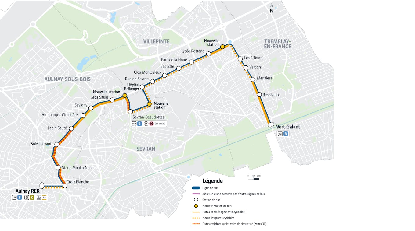
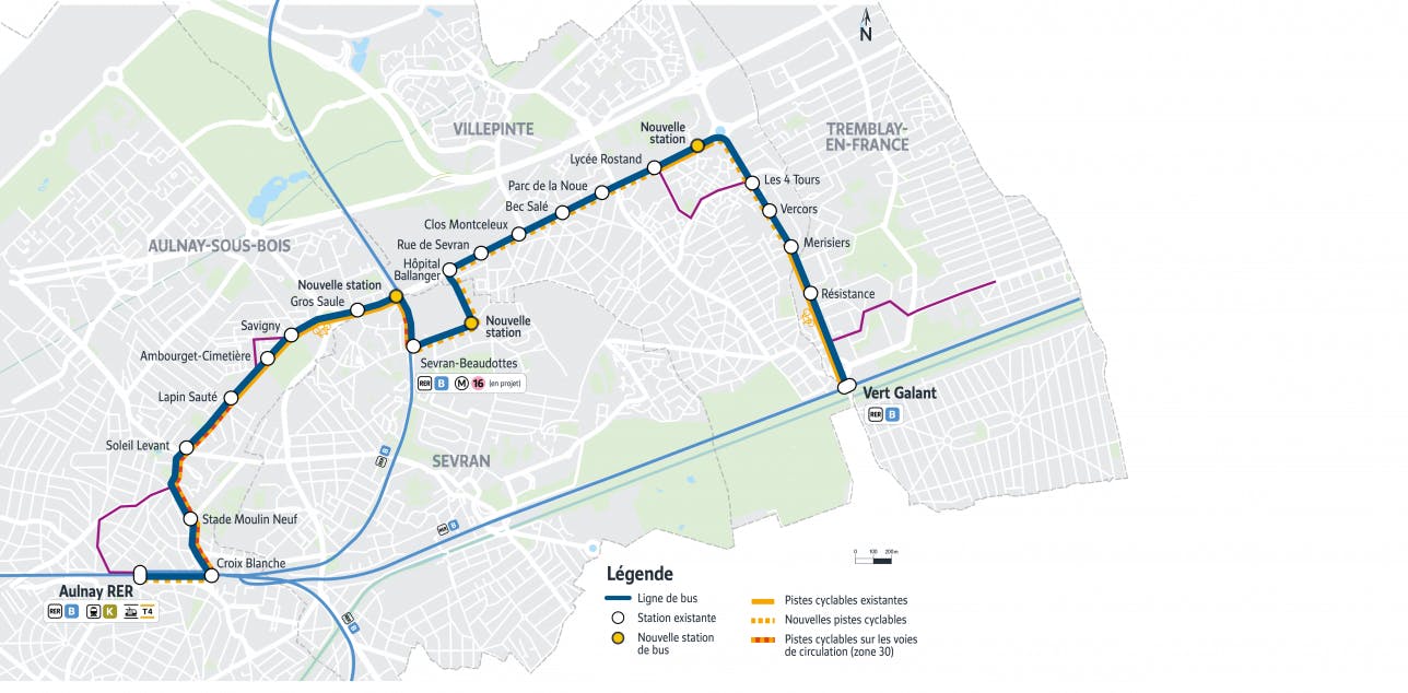
The project consists of creating dedicated bus lanes and specific developments to improve the flow of bus traffic (priority at intersections in sectors shared with private vehicles, for example) between Aulnay-sous-Bois and Tremblay-en-France. The route largely follows the route of the current line 15, between the RER stations of Aulnay-sous-Bois and Vert Galant, passing through the RER station of Sevran-Beaudottes, serving four municipalities (Aulnay-sous-Bois, Sevran, Villepinte, Tremblay-en-France).
The creation of dedicated bus lanes along the 9.2 km of the route and the implementation of specific facilities will improve travel times for users (35 minutes between Aulnay-sous-Bois and Tremblay-en-France and an estimated gain of 8 to 10 minutes) and the performance of the entire bus network in the area. Freed from the vagaries of traffic, the bus will also provide a more efficient service to the major transport hubs in the region (RER B, future line 16 of the Grand Paris Express in Sevran-Beaudottes).
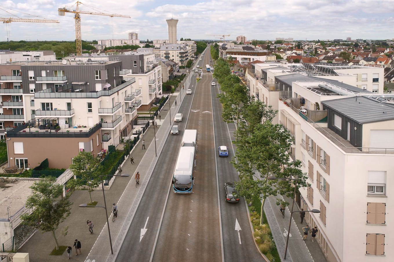
The creation of lanes dedicated to buses will be accompanied by a requalification of public spaces: creation of cycle routes, pedestrian paths, landscaping, etc.
Plan
The objectives of the project
- To offer a fast, reliable and comfortable means of transport and to improve the performance of other bus lines in the territory;
- Ensure an efficient link and connections to the station hubs (Aulnay-sous-Bois; Sevran-Beaudottes and Vert-Galant);
- Support the development projects of the territory by serving as closely as possible the areas in project (in particular the ZAC de la Pépinière and Parc de la Noue);
- Create continuous, comfortable and safe routes for alternative travel such as walking and cycling;
- To improve the living environment by contributing to the renovation of public spaces and the calming of traffic.
The route and the developments
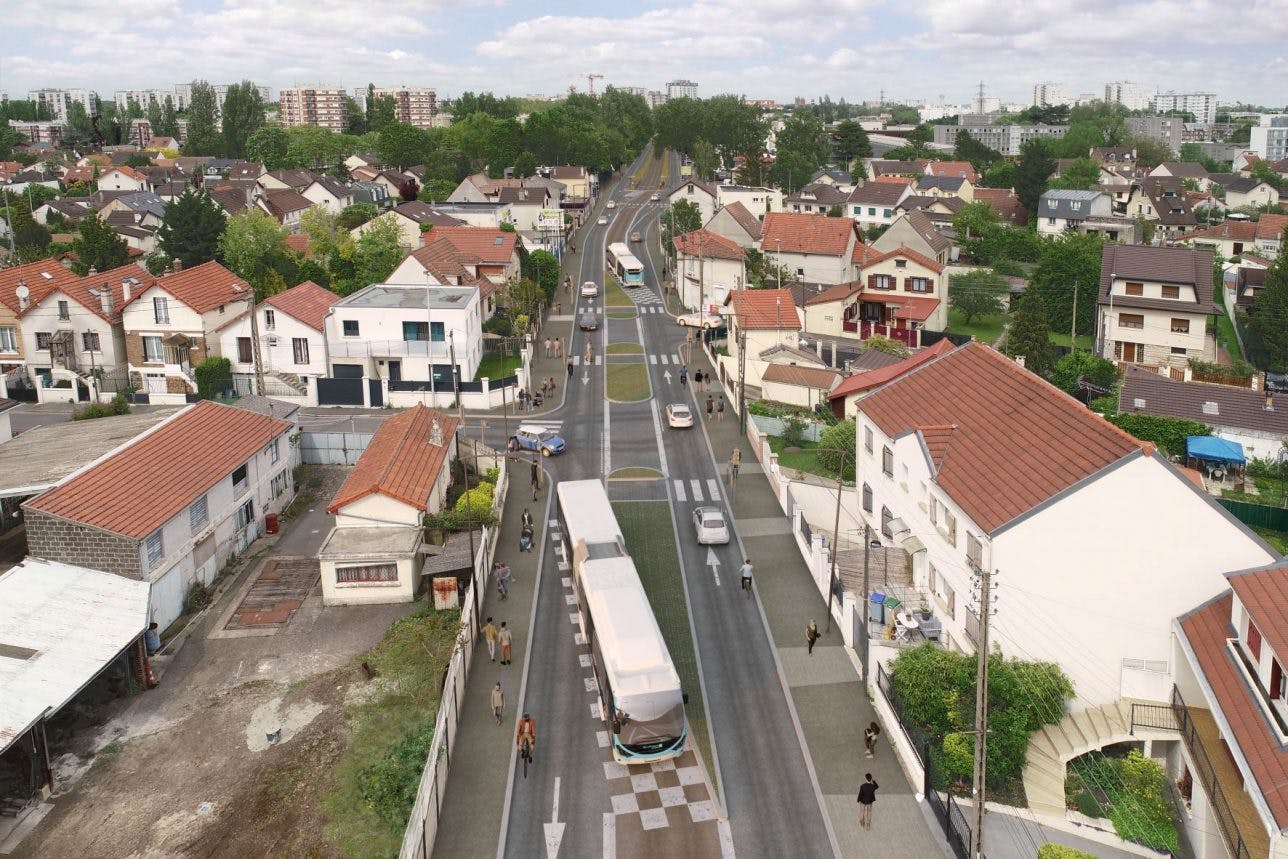
The project is part of a very dense urban environment, with lane widths that are sometimes constrained. As a result, the project provides for several types of insertion of dedicated bus lanes, depending on the environment they will cross and to limit land acquisitions:
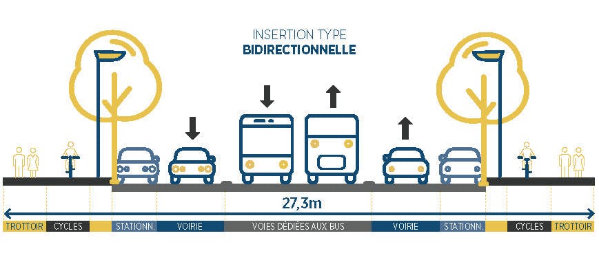
Dedicated bus lanes in both directions
The insertion of dedicated bus lanes in each direction may imply, in some cases, the reduction of traffic lanes, but will allow the creation of cycle lanes or the widening of pedestrian sidewalks. This development option will be chosen in the widest areas, in order to promote a peaceful use of space for all modes of transport (pedestrians, cyclists, cars and collectives).
The lanes dedicated to buses can be positioned axial (the bus lane is in the center with the car lanes on each side) or lateral (the bus lane is on the side).
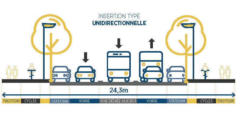
A lane dedicated to buses in one direction
In the most constrained areas, only a dedicated lane will be created so as not to impact the urban environment too heavily. Buses will run in dedicated lanes in one direction, and will run in car lanes in the other direction.
Numerous connections
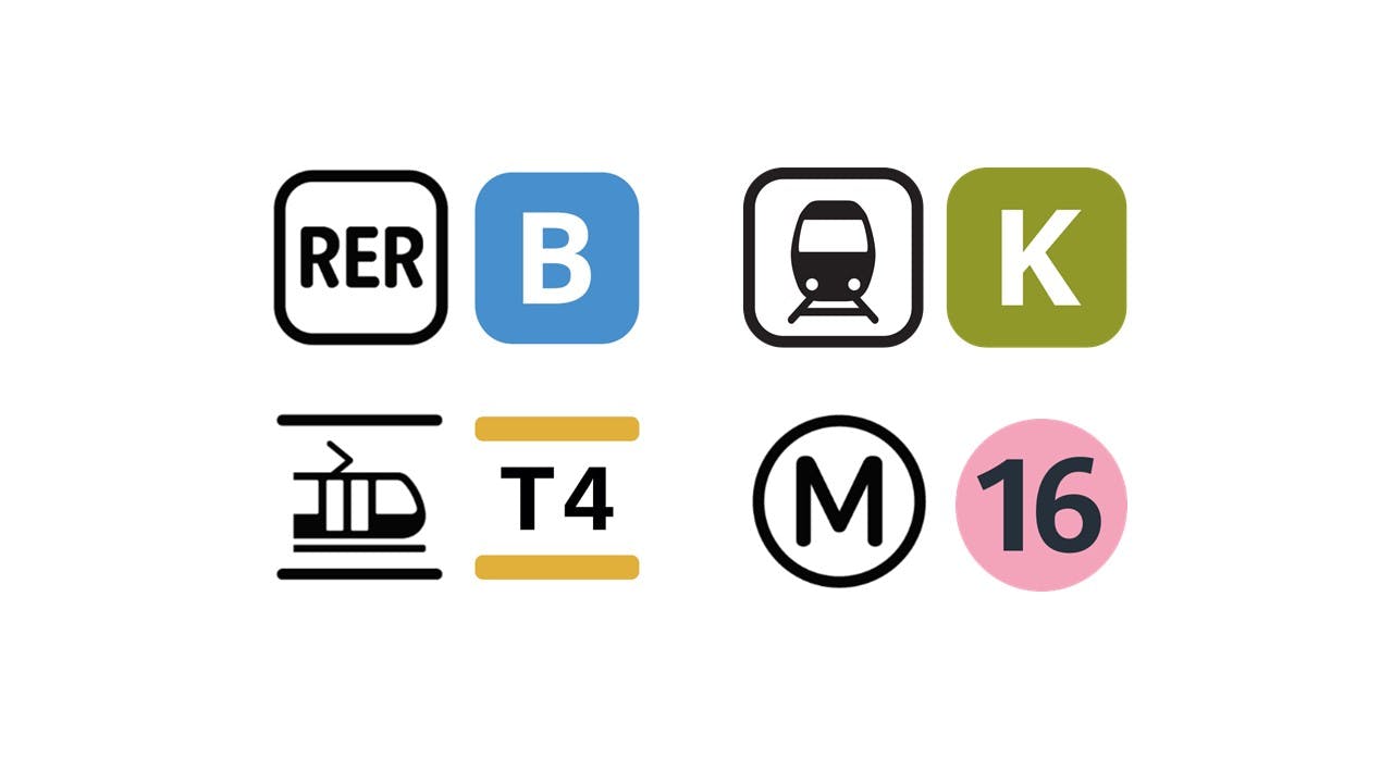
The TCSP will establish numerous connections with the other major modes of transport in the territory, in service and planned: in connection at the RER station in Aulnay: RER B, Transilien K, Tram T4; in connection at Sevran-Beaudottes station: RER B, Future metro line 16 of the Grand Paris Express in project; at Vert-Galant station: RER B.
Connections with buses and the deployment of new cycle routes are also taken into account as part of the project.
A more accessible, fast and comfortable bus
With a bus every five to six minutes during rush hour and an estimated travel time of 35 minutes from Aulnay-sous-Bois to Vert Galant (i.e. a time saving of 8 to 10 minutes), the territory will soon have a fast and efficient means of transport that will best serve the districts and allow easier interconnections with other modes of transport.
The stations and pedestrian facilities will comply with the accessibility standards in force, in order to allow people with reduced mobility to circulate safely.
The project and the bike
Today, the territory suffers from a lack of continuous cycle routes which limits the use of bicycles. The TCSP project plans toconnect the existing cycle sections in order to create continuous cycle routes along the entire route.
With the exception of a 1.5 km zone where bicycles will circulate in the traffic lanes (in a zone limited to 30 km/h), the cycle routes will consist of cycle lanes along the entire route. In total, more than 7.5 km of dedicated roads will be able for cyclists to use in complete safety.
Bicycle parking facilities are planned at each interchange hub.